This is an old revision of the document!
Tropical Storm Emily
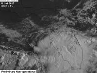
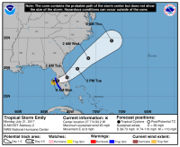
Tropical storm Emily started out as Invest 98L, which formed in the Northeast Gulf of Mexico on July 29, 2017, as a low off of a cold front that dove into the Gulf, which is considered uncommon for the time of year. In the early morning of July 31, 2017, Tropical Depression 6 formed not far off the coast of the Tampa Bay area in Florida with sustained winds of 45 mph and a central pressure of 1008mb.
At 8 am, it strenghtened into Tropical Storm Emily with max sustained winds of 45 mph and a central pressure of 1006mb.
This storm jumped from a low risk to a medium risk just before being named a depression, making it the fastest developed storm of the year as of its formation.
Impacts
Heavy rain is expected throughout Central Florida as a result of landfall, which is expected to be in the afternoon of July 31, 2017.
At 10:45 a.m. on July 31, 2017, Emily made landfall on Anna Maria Island with winds of 45 mph and a min pressure of 1005mb.
Which Model Won?
- ECMWF - Developed the system very weakly, but only had real development once in the Atlantic, so too late of development.
- CMC - Developed the storm in the right area, and maintained a low through the Atlantic after taking it up through the Southeast early on. However, it sniffed the storm first.
- GFS - Saw a weak low, but didn't do anything with it.
- NAVGEM - Also sniffed out the low, but didn't as much as the CMC, nor did it keep it alive and on the right track.
- NAM - Sniffed it out as soon as it could, and had proper pressure, though it went a little north early on.
- UKMET - N/A, but likely like the ECMWF.
- HWRF - Took the storm along proper path as soon as early initialization happened.
- HWRF-PARA - Took the storm North, instead of into the coast of Florida.
- HMON-PARA - Followed the same as the HWRF, but winds were slightly weaker, so not as accurate.
End Result:
- Long range :
- Short range :
- Strength :

