This is an old revision of the document!
Subtropical Storm Alberto
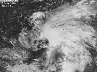
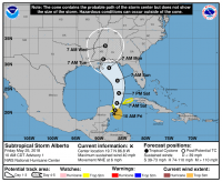
Subtropical Storm Alberto formed at the 11 am advisory on May 25, 2018 to the east of the Yucatan Peninsula with winds of 40 mph and a central pressure of 1005 mb.
Alberto moved Northeast for some time, strengthening slowly off of the coast of Florida before moving NNW and making landfall in the western Florida panhandle as a 45 mph tropical storm. Alberto had a macimum strength of 991 mb and winds of 65 mph a few advisories before landfall occurred.
Alberto weakened into a subtropical depression as it moved into Alabama, then continued on into Indiana, where it became a tropical depression and maintained that status until the morning of May 31, 2018, where Alberto moved into Canada as a remnant low.
Impacts
Alberto made landfall about 15 miles WNW of Panama City, Florida around 3:45 PM on May 28.
Which Model Won?
- GFS - Stuck on a curve right into Florida and going either through the state or up the coast and hooking into AL through SC. Low 1000mbs to ~998mb strength.
- FV3 - Sloppy mess consolidates fast around Florida's big bend, has the same strength as the GFS and meanders about the SE for days.
- CMC - Stronger low, between 988mb and 995mb making landfall between NOLA and Panama City. Moves north slowly and gradually disintegrates.
- ECMWF - Landfall around all of LA to Mobile area as a weak 1000mb to upper 990mbs low. Drifts NE or wanders for a short time.
- ICON - Mid 990mbs low to upper 990mbs low drifting slowly towards TX or LA or Western Gulf.
- NAM - 998mb low moving northward towards Mobile or the FL panhandle.
- HWRF - Strongest model, has 979mb low, strong tropical storm, into W FL panhandle. Moves into S AL and meanders.
- HMON - 998mb low moves and stalls offshore of MS/LA.
- UKMET -
End Result:

